Fil:1973 Atlantic hurricane season summary map.png

Størrelse på denne forhåndsvisningen: 800 × 494 piksler. Andre oppløsninger: 320 × 198 piksler | 640 × 396 piksler | 1 024 × 633 piksler | 1 280 × 791 piksler | 3 000 × 1 854 piksler.
Opprinnelig fil (3 000 × 1 854 piksler, filstørrelse: 3,99 MB, MIME-type: image/png)
| Beskrivelse |
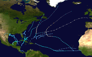
English: This map shows the tracks of all tropical cyclones in the 1973 Atlantic hurricane season. The points show the location of each storm at 6-hour intervals. The colour represents the storm's maximum sustained wind speeds as classified in the Saffir-Simpson Hurricane Scale (see below), and the shape of the data points represent the type of the storm.
Tropical depression (≤38 mph, ≤62 km/h)
Tropical storm (39–73 mph, 63–118 km/h)
Category 1 (74–95 mph, 119–153 km/h)
Category 2 (96–110 mph, 154–177 km/h)
Category 3 (111–129 mph, 178–208 km/h)
Category 4 (130–156 mph, 209–251 km/h)
Category 5 (≥157 mph, ≥252 km/h)
Unknown
Storm type |
| Kilde | Created using Wikipedia:WikiProject Tropical cyclones/Tracks. The background image is from NASA [1]. The tracking data is from the National Hurricane Center's Atlantic hurricane database |
| Opphavsperson | Cyclonebiskit |
| Dette verket har blitt frigitt til allmennheten av opphavspersonen Cyclonebiskit. Dette gjelder på verdensbasis. I enkelte land kan dette være juridisk umulig. I så fall: Cyclonebiskit gir hvem som helst retten til å bruke dette verket for ethvert formål, uten noen vilkår, med mindre slike vilkår kreves ved lov. |
Filhistorikk
Klikk på en dato/tid for å se filen slik den var på det tidspunktet.
| Dato/Tid | Miniatyrbilde | Dimensjoner | Bruker | Forklaring | |
|---|---|---|---|---|---|
| nå | 9. jun. 2013 kl. 20:26 | | 3 000 × 1 854 (3,99 MB) | Supportstorm | Higher resolution |
| 28. sep. 2009 kl. 19:03 |  | 1 024 × 633 (564 KB) | Cyclonebiskit | {{Information |Description={{en|Track map of the 1973 Atlantic hurricane season. The points show the location of the storm at 6-hour intervals. The colour represents the storm's [[:w:maximum sustained wind|maximum sust |
Filbruk
Det er ingen sider som bruker denne filen.
Global filbruk
Følgende andre wikier bruker denne filen:
- Bruk i en.wikipedia.org
- 1973 Atlantic hurricane season
- Template:1973 Atlantic hurricane season buttons
- Tropical Storm Gilda (1973)
- Wikipedia:Good topics
- Hurricane Brenda (1973)
- Tropical Storm Delia (1973)
- Tropical Storm Christine (1973)
- Wikipedia:Featured and good topic candidates/1973 Atlantic hurricane season/archive1
- Wikipedia:Featured and good topic candidates/Featured log/October 2009
- Wikipedia:Featured and good topic candidates/Good log/October 2009
- Wikipedia:Featured topics/1973 Atlantic hurricane season
- Bruk i es.wikipedia.org
- Bruk i pt.wikipedia.org
- Bruk i ru.wikipedia.org
- Bruk i zh.wikipedia.org